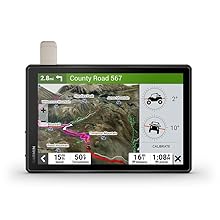
Roam the unknown with Tread XL – Overland Edition. It’s the extra big, extra rugged all-terrain navigator with a 10” ultrabright display with preloaded topography and turn-by-turn trail navigation that routes seamlessly from road to trail. (Limitations may exist in map data for some road and trail route suggestions. Always defer to all posted road signs and conditions during vehicle operation. The Garmin OpenStreetMap products are intended to be used only as a supplementary travel aid and must not be used for any purpose requiring precise measurement of direction, distance, location or topography.)

 |
 |
 |
OFF-ROAD RUGGEDNESSPurpose-built for all-terrain use, this Tread device stands up to anything the elements can throw at it. It’s IP67-rated for water-resistance. |
HIGH-VISIBILITY DISPLAYWith its ultrabright 10” glove-friendly touchscreen, the navigator is designed for easy viewing in bright sunlight or pitch dark. It can be mounted in portrait or landscape mode. |
TRAIL NAVIGATIONEnjoy turn-by-turn trail navigation for traversing unpaved roads and trails using adventure roads and trails map content comprised of OSM and USFS Motor Vehicle Use Maps. |
 |
 |
 |
BUILT-IN INREACH TECHNOLOGYBuilt-in inReach technology offers global satellite communication, two-way text messaging, location sharing and interactive SOS. |
MAPS ON AND OFF-ROADTread includes preloaded topographic maps with 3D terrain for North and South America. It also includes detailed street maps of North America with custom routing for the size and weight of your rig. |
KNOW YOUR BOUNDARIESAccess U.S. public land boundaries for national forests, Bureau of Land Management (BLM), wilderness areas and more. Also, see U.S. private land boundaries and landowner information for parcels greater than 4 acres. |
 |
 |
 |
SATELLITE IMAGERYEnjoy vivid aerial views when you download high-resolution BirdsEye Satellite Imagery directly to your device via Wi-Fi connectivity, with no annual subscription required. |
POINTS OF INTERESTTread comes preloaded with iOverlander points of interest and Ultimate Public Campgrounds, so you don’t need a cell signal to route to the best-established, wild and dispersed campsites. |
ABC SENSORSWhen you’re headed to tough-terrain, the built-in sensors will come in handy — including an altimeter, barometer, compass and pitch/roll gauges. |
Garmin Tread XL Overland, All-Terrain Navigator Specifications
| Display size | 8.5"W x 5.3"H (21.7 cm x 13.6 cm); 10.1" diagonal (25.7 cm) |
| Battery type | rechargeable lithium-ion |
| Display resolution | 1280 x 800 pixels |
| GPS | Yes |
| Physical dimensions | 9.9"W x 7.8"H x 1.2"D (25.2 x 19.9 x 3.1 cm) |
| Weight | 32.8 oz (930 g) |
| Display type | multi-touch, glass, high brightness HD color TFT with white backlight |
| Battery life | Up to 6 hours at 50% backlight; Up to 1 hour at 100% backlight |
| Water rating | IPX7 |
| Preloaded street maps | Yes |
| Navigate-a-track navigation | Yes |
| External memory storage | yes (256 GB max microSD card) |
| Ability to add maps | Yes |
| Dog tracking | yes (when paired to compatible dog track system) |
| Group Ride Mobile | yes (with Garmin Tread app) |
| Includes traffic | yes (with Garmin Tread app) |

Wearable4U Power Pack Bundle
- Wearable4U Power Bank 2200 mAh
- Wearable4U Wall Charging Adapter
- Wearable4U Car Charging Adapter
Keep your devices charged at all times with our Wearable4U Power Bank and the duo Wall & Car USB Charging Adapters.Compatible with all popular USB-powered devices including most smartphones, GPS and fitness trackers, smart watches, wireless speakers, bluetooth headphones, and more.


